
Blog
Battle of Mobile Bay

The Battle of Mobile Bay: A Turning Point in the Civil War
One of the most decisive naval battles of the American Civil War occurred on August 5, 1864, when Rear Admiral David Glasgow Farragut led the Union fleet into Mobile Bay, Alabama. The Chart Showing the Entrance of Rear Admiral Farragut into Mobile Bay, 5th of August 1864, created by Robert Weir and published by Hatch & Co. in 1864, provides a detailed visual representation of this historic engagement. The map illustrates key battle positions, ship movements, and the treacherous waters filled with Confederate defenses, offering an invaluable resource for historians and enthusiasts alike.
The Strategic Importance of Mobile Bay
By 1864, the Confederacy had already lost several major ports, but Mobile Bay remained a crucial stronghold. The city of Mobile was a vital hub for blockade runners supplying the Southern war effort. While Union forces controlled much of the surrounding Gulf Coast, the entrance to the bay was heavily defended by Fort Morgan, Fort Gaines, and Fort Powell, along with a formidable array of underwater mines, then called "torpedoes."
Farragut’s Bold Attack
Admiral Farragut, commanding a fleet of ironclads and wooden warships, faced a daunting challenge. As his fleet advanced, the USS Tecumseh, one of his ironclads, struck a mine and quickly sank. At this critical moment, with his fleet hesitating under fire, Farragut is famously attributed with ordering, "Damn the torpedoes, full speed ahead!" Though the exact wording of his command remains debated, his bold leadership inspired his fleet to press forward, bypassing the torpedoes and engaging the Confederate ships head-on.
The Fall of the Tennessee and Union Victory
A key moment in the battle was the engagement with the Confederate ironclad CSS Tennessee, commanded by Admiral Franklin Buchanan. Despite being heavily armored, the Tennessee was outgunned and ultimately overwhelmed by the combined firepower of the Union fleet. After sustained bombardment and multiple collisions, Buchanan was forced to surrender. With the loss of the Tennessee and the capture of Fort Morgan later that month, the Confederacy lost one of its last major Gulf Coast strongholds.

The Map’s Significance
The Chart Showing the Entrance of Rear Admiral Farragut into Mobile Bay offers a remarkable depiction of this pivotal battle. Created in the same year as the engagement, it provides a firsthand look at the naval maneuvers, ship positions, and the tactical elements of the battle. The map includes detailed illustrations of ship tracks, obstructions, and even small vignettes of key moments, such as the sinking of the Tecumseh and the ramming of the Tennessee.

This chart serves as both a historical artifact and a strategic guide, capturing the intensity and complexity of naval warfare during the Civil War. It remains an essential resource for scholars studying the Union’s blockade strategy and the technological evolution of naval engagements.
Conclusion
The Battle of Mobile Bay was a turning point in the Civil War, cutting off a major Confederate supply line and bolstering Union control over the Gulf Coast. Farragut’s audacious tactics and unwavering resolve exemplified the Union’s naval dominance. The Chart Showing the Entrance of Rear Admiral Farragut into Mobile Bay stands as a testament to this historic battle, preserving its details for future generations.
References
Browning, Robert M. Success Is All That Was Expected: The South Atlantic Blockading Squadron During the Civil War. Dulles, VA: Brassey’s, 2002.
Luraghi, Raimondo. A History of the Confederate Navy. Annapolis, MD: Naval Institute Press, 1996.
McPherson, James M. Battle Cry of Freedom: The Civil War Era. New York: Oxford University Press, 1988.
Thomas Hutchins: The First Geographer of the United States

Thomas Hutchins (1730–1789), the first Geographer of the United States, played a crucial role in early American expansion through his expertise in land surveying and cartography. His work on the Land Ordinance of 1785 and the Seven Ranges survey laid the foundation for the Public Land Survey System still used today. Hutchins’ detailed maps and topographical descriptions guided westward expansion, shaping the nation’s territorial development.
Dutch island of Sint Eustatius in the Caribbean during the American War for Independence
During the American Revolution, the port of Dutch island Sint Eustatius played a pivotal role as a crucial hub for smuggling and trade, significantly impacting the war's dynamics.
Sea Monsters on Old Maps: Myths, Mystery, and Mapping the Unknown
The blog explores the fascinating presence of sea monsters on old maps, highlighting their role in cartographic storytelling."White Woman's Creek" and the Mitchell Map of 1755
How does a place get its name? The name "White Woman's Creek" in Ohio is believed to have historical roots tied to the story of a woman who was captured during a raid by French and Native American forces in the early 1700s. The creek and nearby town's name is linked to Mary, a woman from Deerfield, Massachusetts, who was taken during a raid in 1704.Maps | Battle of Monmouth Original Sold at Auction
Revolutionary War Map to Remain in Private Hands
An original map of the Battle of Monmouth by Michel Capitaine du Chesnoy, the cartographer and aide-de-camp of Marquis de Lafayette, was recently sold at an auction for $486,400. The hand drawn map was purchased by a private collector at an auction held by Northeast Auctions in Portsmouth, New Hampshire.
Our version costs slightly less. Click here to get yours today.
Exhibitions | General Percy’s Map of New York
From August 27, 2014 through to February 2015, the Brooklyn Historical Society will present an exhibition, “Unlocking Two Revolutionary War Era Maps”. The exhibition will include a map of New York used by British General Hugh Percy, who commanded a British Division during the Battle of Long Island. Notations that Percy made before the battle concerning American troop locations are still visible. The map was purchased jointly by the Brooklyn Historical Society and the Green-Wood Historic Fund in 2013. For more on the story of the Percy map, see this recent article in The New York Times.

Percy map detail courtesy NY Times
Click here to get your very own New York Ratzer map.
Hotchkiss’ Shenandoah Valley Map

Detail of Jedediah Hotchkiss’ 1862 Shenandoah Valley Map
In the spring of 1862, Major General “Stonewall” Jackson and his foot cavalry out-maneuvered the Union army by marching over hundreds of miles over the Shenandoah Valley’s roads and putting his forces in positions to win numerous engagements and five major battles. One of the secrets to Jackson's success was his map of the valley, which was created by his chief engineer, Jedediah Hotchkiss. Hotchkiss was a schoolteacher by training, but dabbled in mapmaking as a hobby. At the beginning of the war, he offered his services to the Confederates, and in the spring of 1862, Hotchkiss found himself on Jackson’s staff with one directive: “I want you to make me a map of the Valley, from Harpers Ferry to Lexington, showing all the points of offense and defense in those places.”1 The maps at the time were of little use for military operations, usually commissioned by businessmen or state governments and focused on depicting roads, railroads, and mineral deposits. These surveys were vastly out of date and lacked the topographic detail needed for military operations. Hotchkiss was given a wagon and a driver to complete his reconnaissance and the result would be a map on linen, stretching over eight feet long and depicting all the fords, terrain and roads that allowed Jackson's command to make his lighting movements up and down and around the valley.

Bibliography:
Kagan, Neil, and Stephen G. Hyslop. National Geographic Atlas of the Civil War: A Comprehensive Guide to the Tactics and Terrain of Battle. Washington, D. C: National Geographic Society, 2009. Print.
Footnotes:
1Kagan, Neil, and Stephen G. Hyslop. National Geographic Atlas of the Civil War: A Comprehensive Guide to the Tactics and Terrain of Battle. Washington, D. C: National Geographic Society, 2009. Print.
Maps of HMS Phoenix
This is the initial entry in a series about the H.M.S. Phoenix, a 44 gun, 5th rate Frigate that was one in a long line of ships with the same name to serve in the Royal Navy. The series will cover the actions of the Phoenix during the American War of Independence and the maps that are relevant to her service.
The Phoenix entered British service in 1759, with her first action against the French during the Seven Years War. The summer of 1775 saw the start of the American rebellion and the British Army under siege in the city of Boston. With just 26 ships, Vice Admiral Samuel Graves, commander of the North American Station, needed re-enforcement, so the Admiralty dispatched the Phoenix to America. Accurate charts of the North American coast were also needed and the Admiralty gave the Captain of the Phoenix, Hyde Parker, fifty charts of the Boston Harbor by J.F.W. Des Barres.
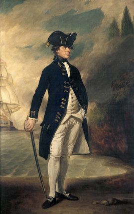
Captain Hyde Parker
Sailing conditions during the winter on the north-eastern coast of North America were unpredictable and dangerous and accurate charts were needed to reduce the risk to ships. Des Barres was already working on producing an atlas of the North American coast for the admiralty called the Atlantic Neptune. Given the situation in Boston Des Barres published the chart of the Boston Harbor separately in August and fifty charts were rushed to the Phoenix before she sailed for America. Parker and the Phoenix delivered the charts early in November 1775.
The Boston chart was created using surveys conducted by Samuel Holland and George Callendar during the 1760s. The complete Atlantic Neptune would be published in 1777.
Bibliography:
Gates, W. (1905). Ships of the British Navy: A Record of Heroism, Victory and Disaster, Volume 2 (Vol. 2). Portsmouth: W.H. Long.
"CAPTAIN (later Admiral) SIR HYDE PARKER, Kt (1739- 1807) by George Romney, (1734-1802) on the Staircase at Melford Hall." National Trust Prints. Accessed December 12, 2014. http://www.ntprints.com/image/347611/captain-later-admiral-sir-hyde-parker-kt-1739-1807-by-george-romney-1734-1802-on-the-staircase-at-melford-hall
Hornsby, Stephen J. Surveyors of Empire: Samuel Holland, J.F.W. Des Barres, and the Making of the Atlantic Neptune. Montréal, Québec: McGill-Queen's UP, 2011. Print.
"A Chart of the Harbour of Boston | Library of Congress." A Chart of the Harbour of Boston | Library of Congress. Accessed January 8, 2015. http://www.loc.gov/item/75693436/
"Atlantic Neptune." Wikipedia. Wikimedia Foundation, 29 Nov. 2014. Web. 12 Dec. 2014.
- See more at: https://www.battlemaps.us/blog/maps-of-hms-phoenix/#sthash.sIELUWEM.dpufMilitary Engineers | Sir Thomas Hyde Page

Captain Sir Thomas Hyde Page (1746-1821) by James Northcote
Captain Sir Thomas Hyde Page was born in the City of Westminster in 1746. He followed in his father’s footsteps and became a military engineer after attending the Royal Military Academy in Woolwich. He was first cadet at the academy and received a gold medal from George III for his efforts. Upon graduation in 1769, he was appointed to Sub-lieutenant in the Royal Engineers, and in 1774 was promoted to Second Lieutenant and worked on civil engineering projects in England.
Page served in America as aide-de-camp to General Pigott, who commanded the British left flank in the Battle of Bunker Hill in June, 1775. Page was wounded by a cannon ball during the battle and lost his leg below the knee and was evacuated to England. During this recovery, he drew a series of maps of the actions around Boston. In 1790, Lieutenant Colonel John Small wrote to Page about the day he was wounded:
“The interesting position we were placed in side by side at the memorable Battle of Bunker’s Hill will never be forgotten, and will ever excite the most anxious emotions in the breast of the fellow campaigner who has now the honour of addressing you; who witnessed in the most trying moments, your innate worth, your professional intrepidity and skill, and was most seriously affected when at your side he saw you fall from a very dangerous wound, receiv’d when displaying your exertions in the field, when your cool and manly example, and sound judicious advice, contributed much to acquire success and victory.”
Page was awarded a pension of ten shillings per day for his disability, and he continued in the service of the Army working on engineering projects. He was knighted in 1783 for his service to the country and ended his military career with the rank of Captain in 1787, when he was placed in the invalid engineers. Page continued to consult on engineering projects around the United Kingdom and retired to France where he died in 1821. He was buried in the city of Boulogne, France.
Bibliography:
Rix, Herbert, “Page, Sir Thomas Hyde (1746–1821)”, Rev. W. Johnson. In Oxford Dictionary of National Biography, edited by H. C. G. Matthew and Brian Harrison. Oxford: OUP, 2004. Online ed., edited by Lawrence Goldman, http://www.oxforddnb.com/view/article/21097 (accessed July 23, 2014).
History of the Corps of Royal Engineer by Whitworth Porter MG Royal Engineers Volume I, London Longmans, Green and Co. New York 1889
Footnotes:
1 History of the Corps of Royal Engineer by Whitworth Porter MG Royal Engineers Volume I (London Longmans, Green and Co. New York 1889), 204.